Starting from the Cantabrian Sea, Bisaurin is the first peak of the mountain range that exceeds an altitude of 2,600 meters,
TECHNICAL DATA
Location: Western Pyrenees. Altitude: 2,669 meters.
Altitude difference: 1,200 meters. Duration: 2,45 hours.
Access: Aragües del Puerto. Starting point: Llano de Lizara (1,540).
Refuge: Lizara (1,540) Ayunt. Aragties.
Season: June to October
Cartography: Alps, Ansó-Hecho. Terrain: grassy, stony and rocky.
Difficulty: medium.
Effort: medium. Risk: medium
Equipment: low mountain
Approach
In Puente la Reina de Jaca take the A-176, which goes through the Echo Valley, and after 16 km change to the Aragües del Puerto, which goes for another 7 km and 10 km through a dense forest until, after a series of tight bends, it ends in the Llano de Lizara next to the refuge of the same name (1,540).
Itinerary
On one side of the refuge runs a signposted path. We follow it along a grassy hill and above the edge of the forest we come across a path that disappears next to a watering hole with a fountain (1,700). Continuing on a path, we round the head of the valley with a slight climb. After bypassing a stream, the path gains altitude.
Gains altitude in a winding route along the grassy slope until we find another waterhole with a well (1,950). Then it follows a broken line to reach the pass Collado de Foratón (2,033). Following the hill next to a wire fence, immediately begins the climb to the southern ridge. The first section is grassy, the next is rocky and very steep, but the path always remains the path that leads to the compact limestone ridge of Visaurín
Other itineraries
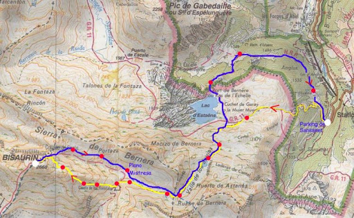
Even if the return route is longer, it is worth continuing along the ridge to the eastern summit (2,654), descending to Plano Mistresa and circling the Visaurin massif to the east to return to the starting point. Visaurin is usually also climbed from the Echo Valley, using the Gabardito Hut (1,360) as the starting point.